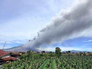
When Mount Sinabung roars back to life, nobody living near the slopes in Karo District gets any breathing room. The volcano on Indonesia’s Sumatra island erupted violently, sending a thick column of black ash and smoke soaring 3,500 meters into the sky. While initial reports confirmed zero casualties, the reality on the ground is far more complex than a simple "all clear" headline.
Thousands of tons of heavy ash have blanketed roads, vehicles, and agricultural fields across North Sumatra. If you think a distant explosion has no direct bearing on everyday survival, you haven't watched volcanic debris choke local farming communities.
What Happened During the Latest Eruption
The eruption hit at 10:17 a.m. Western Indonesian Time, lasting just over an hour. Geological authorities quickly raised the volcano's alert status from Level II (Watch) to Level III (Alert) as seismic indicators pointed toward prolonged instability.
Lana Saria, chief of Indonesia's Geological Agency, pointed out right away that this blast functioned as an initial warning. Larger explosions remain entirely possible.
- Ash Plume Height: 3,500 meters above the summit.
- Evacuations: Over 600 villagers relocated to emergency shelters in Sukatepu Village.
- Exclusion Zones: Strict bans on all activities within 3 kilometers of the peak and up to 6 kilometers along the southeast sector.
Local authorities distributed protective masks immediately, but ashfall already compromised visibility and air quality in villages like Kuta Tengah and Payung.
The Immediate Danger Facing Sumatra Communities
Volcanic blasts grab global attention for a few hours, but the real test begins once the ash settles. Agriculture takes the hardest hit. Vegetable crops across Karo District—famous for supplying regional markets—are smothered in abrasive ash. Farmers face massive financial losses when leaves are stripped and soil chemistry changes overnight.
Air travel also takes a direct hit. Flights between Jakarta and North Sumatra's Kualanamu International Airport faced swift disruptions and cancellations as drifting plumes threatened jet engines.
"This eruption is considered an initial eruption, and it is possible that a larger eruption could occur."
That warning from the Geological Agency isn't corporate boilerplate. It's a blunt reality check for anyone thinking about visiting Lau Kawar Lake or hiking near the slopes. Recreation sites are closed indefinitely for a reason.
Why Sinabung Keeps Waking Up
Located on the volatile Pacific Ring of Fire, Indonesia hosts more than 120 active volcanoes. Sinabung spent centuries completely dormant before shocking scientists by waking up in 2010. Since then, it has maintained an unpredictable cycle of dangerous pyroclastic flows and towering ash columns.
People often ask why communities don't just pack up and leave permanently. The answer is tied to volcanic soil fertility. Generations of farmers return because the land produces incredible harvests, despite the constant threat hanging overhead.
The National Disaster Mitigation Agency (BNPB) deployed hundreds of personnel alongside joint response teams to manage shelters and distribute basic supplies. The Health Ministry activated emergency centers loaded with oxygen concentrators and nebulizers to fight respiratory problems caused by fine silica dust in the air.
What You Need to Know Moving Forward
If you are tracking seismic hazards in Southeast Asia or planning travel to Sumatra, keep these practical points in mind:
- Obey Exclusion Boundaries: Never cross the established 3-to-6-kilometer safety zones around the summit. Local enforcement is strict.
- Watch for Cold Lava Flows: Heavy seasonal rains mixed with fresh volcanic ash create dangerous lahar flows along local river basins. Stay far away from rivers during downpours.
- Prioritize Respiratory Protection: If you're in the affected region, keep N95 masks handy and monitor local health updates closely.
Stay clear of the danger zones and heed official disaster warnings before the mountain decides its next move.


