A Slow-Moving Threat Brewing in the Gulf
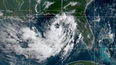
Tropical Storm Bertha formed on July 20, 2026, roughly 110 miles south of Panama City, Florida, packing 40 mph sustained winds. On paper, a weak tropical storm with 40 mph winds sounds like something you can easily sleep through.
That is a dangerous mistake.
While everyone focuses on wind speed and Saffir-Simpson categories, the real danger here isn't gale-force gusts ripping off roof shingles. It's the speed—or lack thereof—at which this system is dragging itself across the northern rim of the Gulf of Mexico. Drifting west-northwest at a crawling 3 mph, Bertha is set to stall and park itself over coastal communities for days.
When a tropical system moves at walking speed, it acts like a giant atmospheric sponge hovering over the ocean, continuously soaking up moisture and dumping it over the exact same stretch of land for 72 hours straight.
The Hidden Danger of Crawling Tropical Systems
Forecast models from the National Hurricane Center show rainfall totals between 4 to 8 inches, with isolated pockets reaching up to 12 inches through Friday across southern Florida, Alabama, Mississippi, Louisiana, and middle Texas.
When a storm moves fast, 8 inches of rain gets spread across three states in twelve hours. When a storm crawls at 3 mph, 8 inches of rain falls on a single parish or county that already has saturated soil.
Expected Rainfall: 4 - 8 inches (Isolated totals up to 12 inches)
Storm Surge Threat: Up to 4 feet in low-lying coastal zones
Current Forward Speed: ~3 mph (West-Northwest)
Active Watches: Tropical Storm & Storm Surge Watches from FL Big Bend to LA
Coastal soil across Louisiana and Mississippi can't absorb water at that rate. Drainage canals in low-lying cities fill up fast, turning street-level downpours into urban flash floods in a matter of hours.
Storm Surge Risks Beyond the Wind
A storm surge watch stretches from the mouth of the Mississippi River to the Alabama-Florida border. The National Hurricane Center warned of potential storm surge up to 4 feet in vulnerable coastal zones.
Combine a 4-foot surge push from the south with 10 inches of rain draining down from the north, and you get a classic hydrologic sandwich. The inland water has nowhere to go because the rising sea level blocks the outlets.
Summer Travel Chaos at Peak Tourism Season
Timing is everything. Bertha hit during late July, right at the absolute peak of the summer beach vacation window.
Millions of tourists are currently crammed into short-term rentals, beachfront hotels, and coastal resorts along Panama City Beach, Gulf Shores, and Orange Beach. Most out-of-state visitors don't pay attention to tropical updates unless a Category 3 hurricane is headline news. They see "Tropical Storm" on the weather app, assume it's just an annoying rainy afternoon, and head out to drive on flooded coastal highways.
- Flight Delays and Gate Holds: Regional hubs like Pensacola, Mobile, and New Orleans are already bracing for ground stops and localized flight cancellations.
- Rip Currents: Local beach patrols along Florida's Panhandle have raised double red flags, but tourists frequently ignore beach closures, resulting in hazardous water rescue situations.
- Road Closures: Highway 90 and low-lying coastal access routes across Mississippi and Louisiana are at high risk of tidal overflow.
Emergency crews in Escambia County, Florida, spent Monday distributing free sand and sandbags to residents in low-lying areas. Local authorities know from hard experience that slow storms cause far more water damage than quick-moving hurricanes.
What You Should Do Right Now
If you live along the northern Gulf Coast or you're currently visiting for summer vacation, don't wait for a formal hurricane warning to take action.
- Move Vehicles to Higher Ground: If your rental or house sits in a flood zone, move your car immediately. Standing water on coastal streets rises faster than you think.
- Download Offline Radar Apps: Power outages from localized severe squalls and isolated tornadic activity in the Florida Big Bend can knock out cell towers.
- Monitor River Gauges: If you live inland along small rivers or bayous in Louisiana or southern Mississippi, keep an eye on hydrographs. Crests often happen 24 to 48 hours after the storm center passes.
- Obey Double Red Flags: Stay completely out of the Gulf waters. Deep ocean swells generated by Bertha are creating life-threatening rip currents across the entire northern coastline.
Track official updates directly through the National Hurricane Center rather than relying on social media rumors, and prepare for prolonged power flickers and localized travel halts through the end of the week.